


tour de combleroufle depuis la vacherie

alinetpierre
User
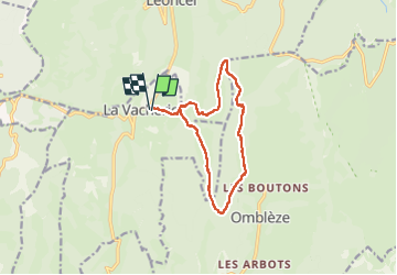

Length
12.5 km

Max alt
1419 m

Uphill gradient
875 m
Km-Effort
24 km

Min alt
849 m

Downhill gradient
875 m
Boucle
Yes
Creation date :
2024-04-11 06:43:53.755
Updated on :
2024-04-11 13:52:37.435
4h15
Difficulty : Difficult

FREE GPS app for hiking
 SityTrail
IGN / Geographical institutes
SityTrail Plus
The world is yours!
About
Trail Walking of 12.5 km to be discovered at Auvergne-Rhône-Alpes, Drôme, Le Chaffal. This trail is proposed by alinetpierre.
Positioning
Country:
France
Region :
Auvergne-Rhône-Alpes
Department/Province :
Drôme
Municipality :
Le Chaffal
Location:
Unknown
Start:(Dec)
Start:(UTM)
672634 ; 4972720 (31T) N.
Comments